LiDAR for UAV
The production of aerial surveys, used in various fields of activity from engineering surveys to forestry, is currently developing dynamically. As a remote and mobile data collection method, drone surveying has a number of obvious advantages in comparison with classical geodetic methods, namely in terms of the speed of work and the ability to survey hard-to-reach and dangerous areas.
Airborne laser scanning (hereinafter - ALS) is one of the types of aerial surveys. The sensor installed on the aircraft conducts discrete scanning of the terrain and objects located on it. In this case, the direction and time of passage of the laser beam are recorded. In addition to LiDAR, the scanning system includes a high-precision GNSS receiver and an inertial unit (IMU), which determine the current position and orientation of the laser scanner. Knowing the orientation angles and coordinates of the laser scanner, one can unambiguously determine the absolute coordinates of each laser reflection point in space by solving the direct geodetic problem. The scanner pulses frequency is hundreds of thousands of Hz. Due to the high discreteness and density of points of laser reflections, the user of the ALS technology has the ability to obtain points of laser reflections (hereinafter – Point Clouds) from the relief under the crowns of trees, which is physically impossible when using the aerial photography. It is also important to note the independence of the ALS method from lighting conditions.
Depending on the tasks related to the configuration and availability of survey objects, the scanning system can be installed on various types of unmanned aerial vehicles (hereinafter referred to as UAVs), which differ in the type of wing (copters, fixed wind or hybrids), type of takeoff / landing and type of engine. In specific conditions, the features of the flight capabilities of each of the listed types of UAVs may have an advantage over the capabilities of the others. For example, fixed wing type carriers provide high speed and output, but are limited by the need to find a suitable take-off / landing site. due to the variety of application conditions for a scanning system, an important feature is its cross-platform and the possibility of using it on a wide range of UAV types. AGM Systems LLC offers the AGM-MS series (Table 1) for ALS from UAVs.
Table 1. LiDARs for UAVs. Specifications
| Specification |
AGM-MS1 |
AGM-MS3
|
| Scanning frequency, kHz |
300 |
640
|
| Maximum measurement range, m |
100 |
300
|
| Scanning mirror rotation speed, Hz |
20 |
20
|
| Ability to integrate an external camera, pcs |
1 |
2
|
| Inertial positioning system |
AGM-PS.M33 |
AGM-PS.M37
|
| Metrological characteristics
|
| Spatial accuracy, cm |
3-5 |
3-5
|
| Dimensions, mm |
141x112x112 |
120x116x104
|
| Power supply |
9-18V, 1.3A |
9-18V, 1.3A
|
| Operating temperature |
-10...+50 °C |
-20...+55 °C
|
The entire procedure for outputting remote sensing data (point clouds, external orientations) is carried out in software products of our own design (Fig. 1).
Fig. 1. Software supplied with AGM-MS series scanning systems
Let's consider some of the successfully proven options for installing systems on various types of drones.
Multirotor UAVs. Possessing a vertical takeoff/landing type, such carriers are least limited by the choice of a suitable site for the start and end of a flight task. The maneuverability of this type of device at relatively low speeds is indispensable in difficult terrain, if it is necessary to go around it at low altitudes. Table 2 shows the specifications of two UAV models of the described type: Geoscan 401 (Fig. 2) and DJI Matrice 300 Pro (Fig. 3).
| Characteristic |
Geoscan 401 |
DJI Matrice 300 Pro
|
| Motor type |
electric |
electric
|
| Cruise carrier speed, m/s |
10 |
10
|
| Survey area for one flight, ha |
150-200 |
100-150
|
| Manufacturer |
Geoscan LLC, Russia |
Shenzhen Dajiang Innovation Technology Co, China
|
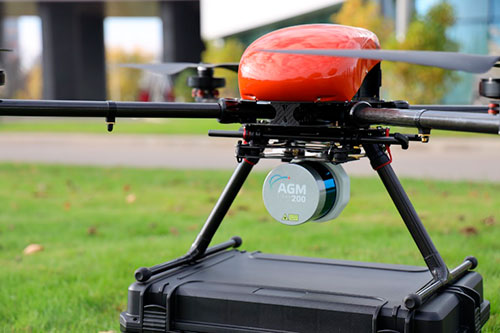
Fig. 2. AGM-MS series system installed on Geoscan 401 UAV
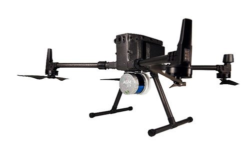
Fig. 3. AGM-MS series system installed on the DJI Matrice 300 Pro UAV
Fixed wing drones. The ability to enjoy a significant advantage over copter-type UAVs in speed is both obvious and undeniable. However, there are a number of features that require special attention. Taking off from a pneumatic or manual catapult, landing with a parachute - all these procedures, firstly, require separate deep technical training of UAV operators, and secondly, during their implementation there are much more opportunities for emergency situations with potentially negative consequences for the payload than when working with multicopter devices. Figures 4, 5 show examples of installation of AGM-MS series scanning systems on Supercam S350 and Ptero G1 UAVs. Table 3 - comparison of individual specifications.
| Characteristic |
Supercam S350 |
Ptero G1
|
| Flight time, h |
up to 3 |
up to 15
|
| Cruise carrier speed, km/h |
85 |
95
|
| Survey area for one flight, km2 |
up to 20 |
up to 400
|
| Manufacturer |
Unmanned Systems Group, Russia |
Ptero LLC, Russia
|
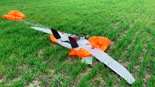
Fig. 4. AGM-MS series system installed on the Supercam S350 UAV
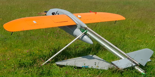
Fig. 5. AGM-MS series system installed on the Ptero G1 UAV
Hybrid Drones (VTOL). Combining the advantages of the two types of drones listed earlier, vertical takeoff / landing devices occupy a significant place among carriers. Takeoff/landing of aircraft of this type, as a rule, is carried out using electric motors according to the principle of a multicopter UAV, and movement along the working route is carried out after starting a sustainer engine (gasoline or electric) according to the principle of an fixed wing UAVs. Figures 6, 7 show examples of installing AGM-MS systems on Supercam SX350 and JOUAV CW-25 drones. Table 4 - comparative specifications.
Table 4. UAVs with vertical takeoff/landing (VTOL)
| Characteristic |
Supercam SX350 |
JoUAV CW-25
|
| Flight time, h |
up to 2 |
up to 6
|
| Cruise carrier speed, km/h |
70-120 |
100
|
| Survey area for one flight, km2 |
up to 20 |
up to 60
|
| Manufacturer |
Unmanned Systems Group of Companies, Russia |
Chengdu JOUAV Da Peng Tech Co. Ltd., China
|

Fig. 6. AGM-MS series system installed on the Supercam S350 UAV

Fig. 7. AGM-MS series system installed on the JOUAV CW-25 UAV
Depending on the map scale, application and survey conditions, the UAV LiDAR can be installed on most types of aircraft without compromising the quality of the received data. The high efficiency of the use of ALS in the design and arrangement of industrial facilities of various kinds has been repeatedly proven in practice by numerous users who actively use scanning systems of the AGM-MS series on dozens of drone models, including due to practically unlimited reasonable reasons for installation and hardware integration.